Bush-bred, but with an eye for the world, John Rymill melded the old with the new to redraw the map of the Antarctic Peninsula.
Story Mark Muller
John Riddoch Rymill was born on Penola Station in 1905 and grew up self-reliantly in the South Australian bush before attending boarding school in Melbourne. At the age of 18 he travelled to England, the world centre of polar exploration, determined to become a polar explorer. Once asked why, he could only reply that it had been his ambition for as long as he could remember.
There was no appropriate tertiary course available for aspiring young explorers, so Rymill set about designing one for himself. Despite dyslexia, he learnt to survey and navigate at the Royal Geographical Society in London, to ski and mountaineer in Switzerland, and to sail in Essex. He was back in Australia in 1927 when he won the National Skiing Championship at Mount Kosciuszko. Returning to England, he studied nutrition and cooking in Cambridge, bookkeeping and anthropology in London, and learnt to fly.
In 1929, with his powerful 193-centimetre physique capable of easily carrying an 82-kilogram pack, he joined a three-month Cambridge University anthropological collecting expedition to northern Canada, where he had recently spent time travelling and hunting.
Rymill next won a position as pilot and surveyor on the 1930-31 British Arctic Air Route Expedition, investigating the terrain and meteorology of Greenland beneath the proposed Great Circle air route between Britain and North America. Living among the Eskimos and gaining their respect, he took every opportunity to learn their techniques for polar travel and survival. Rymill, with his sights already set on the Antarctic, and with an appreciation of First Nation peoples from his time in Canada, subsequently recounted in a radio talk: “I took every opportunity to go out with the Eskimos ... to learn their techniques of travelling and hunting, and living comfortably in the cold. This experience was of great value to us later when we met similar conditions in western Antarctica.”
The expedition culminated in his epic 700-kilometre crossing of the featureless, 3000-metre high Greenland Ice Cap with sledge and huskies. In 1932, Rymill assumed command of a similar expedition after the leader was killed in a hunting kayak. He also, incidentally, introduced lightweight kangaroo-hide Australian bullock whips to the Eskimos to help drive the dogs more efficiently.
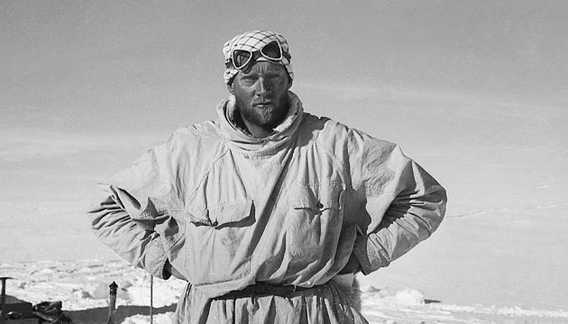
Impressive as this all is, Rymill’s foremost achievement was, at the age of 29, to raise the necessary funds and lead the independent 1934–37 British Graham Land Expedition to the Antarctic. This hostile and uninhabited region, far to the south of Cape Horn, was the last major geographical feature on the earth’s surface still to defy human discovery. Graham Land was thought to be an archipelago, comprising a massive 3000m mountain range rising precipitously from the ocean. Its hundreds of miles of surrounding pack ice had rendered it inaccessible, crushing the ships and impeding the progress of all previous explorers.
Rymill’s 16-man team mounted a three-year endeavour aboard its small, 150-ton sailing ship, the Penola. With an average age of 25, some were serving military officers, some were young Cambridge science graduates, and others were specialists in their various fields. To ensure they all fully realised what they were letting themselves in for, Rymill asked each to provide his own three-year supply of toilet paper.
The expedition combined the ancient Eskimo technique of husky-powered sledges with the modern technology of radios and an aircraft. “My plan,” Rymill said, “was based on the fact that the katabatic winds – fierce local winds (we recorded their velocity at times up to 130 miles per hour) blowing down from the high Graham Land plateau – would blow the heavy pack-ice away from the [west] coast, leaving a narrow strip of open water. This was sometimes less than a mile wide, but we hoped it would be possible to work a small ship down the coast, through the rocks and skerries near the shore. The success of this operation would depend on careful reconnoitring with an aeroplane ...”
His bold assumption proved correct. After aerial reconnaissance, the Penola was indeed able to manoeuvre down the coast. Island bases were then established from which, the following winter, sledging parties could skilfully travel over the thin, newly frozen sea ice.
The expedition successfully surveyed nearly 2000km of previously unexplored coastline, establishing that Graham Land was not an archipelago but, in fact, the Antarctic Peninsula. As part of that achievement, Rymill and his companion Edward ‘Doc’ Bingham crossed its glaciated, igneous mountains to the east coast.
This story excerpt is from Issue #124
Outback Magazine: April/May 2019