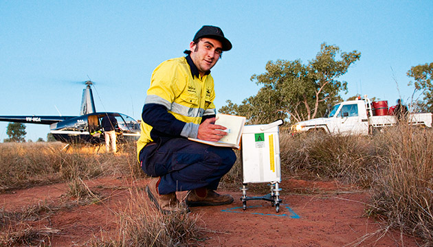
Using air and ground vehicles, crews from Daishsat Geodetic Surveyors work their way across the country using GPS to guide them as they map the gravity field of the Earth’s surface.
Story By Annabelle Brayley
Gravity mapping is not a new technology. Its purpose is to create an image of the density of the earth at any given point. However, until the latter part of the 20th century, it was a cumbersome process wherein surveyors had to physically measure the grid they were plotting and then, after taking a reading, transfer the data onto ground maps using complicated mathematical formulae.
In the late 1970s, the US military introduced the Global Positioning System (GPS), which indirectly revolutionised gravity surveying. One of those who recognised the potential GPS had for mapping and surveying was David Daish. He started his own business, Daishsat Geodetic Surveyors, 19 years ago. “The early GPS machines were about the size of a suitcase but over the years the receivers have become much more elegant,” he says.
GPS made gravity surveying relatively cheap and highly accurate. Some of Daishsat’s contracts are with state governments, which make the images publicly available. Mineral, oil and gas companies are the other obvious contenders but David notes that the images are also useful in the search for hot thermal rocks and groundwater exploration. Daishsat also provides airborne magnetic and radiometric imagery, which maps the magnetic field. Potassium, uranium and thorium give off radiation, which shows up on these images, a process that contributed to the discovery of deposits at what is now South Australia’s Olympic Dam mine.
Explaining the gravity mapping process, David says, “There are two aspects to it. Gravity changes with height so, to accurately measure gravity beneath the surface, you must have accurate height. We use the GPS to get accurate position and height. Then, inside the gravity meter, there is a vacuum chamber in which two plates are held apart by a very thin quartz spring. It’s temperature-controlled so that it’s constant and stable. One plate’s fixed and one moves, and the mobile plate moves nanometres [one billionth of a metre] in response to the gravity/mass beneath the surface. The data from the gravity meter is regularly uploaded to our server in Western Australia where it’s processed and at the end of the day we have working images.”
This story excerpt is from Issue #80
Outback Magazine: Dec/Jan 2012