Remote communities are embracing new technology to collect environmental data, giving them a stronger voice in land management.
Story By David Hancock
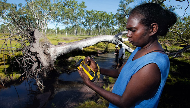
Near Broome, WA, sea rangers are using cutting-edge hand-held technology to count turtles and dolphins. With the same technology, another group of rangers in the Gulf of Carpentaria is conducting a survey of shore birds that have migrated from Siberia, while in western Arnhem Land Indigenous land managers are using the technology to record early dry-season burns.
All are using personal digital assistants (PDAs) linked via satellite to a global positioning system (GPS). The PDAs use Cybertracker, a software package developed in South Africa for highly skilled, but often illiterate animal trackers who work with scientists and information-technology experts to create a sophisticated data-collection system. The software has an icon-based interface that enables expert non-literate trackers to record complex geo-referenced observations about animal behaviour and remote activities.
Cybertracker is a free, intuitive software system that enables any user group to customise data collection to its own region or circumstance. It can be used to collect data about feral animals, weeds, biodiversity, burning and myriad other issues. Many ranger groups and communities in northern Australia have embraced it.
This Story is from Issue #95
Outback Magazine: June/July 2014